

Regularization of unauthorized forest structures: Guide to completing the application
Forest maps in most areas of the country have become an unsolvable puzzle, and the government is waiting for the green light from the Council of State in order to proceed with resolving issues primarily related to property ownership, illegally cleared land, and unauthorized structures in forests.
For this reason, the government “delayed” the posting – revision of forest maps until the end of December 2021, in order to create a secure legislative framework that will not conflict with constitutional requirements and will provide solutions to the problems for the completion of the forest maps and land registry project.
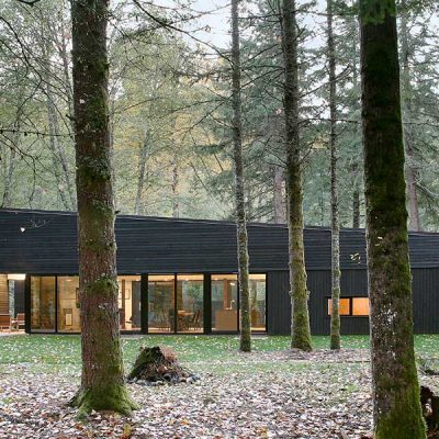
One of the biggest “thorns” is the illegal construction of buildings in forests. It is estimated that over 150,000 illegal buildings have been constructed on land that was forested, based on aerial photographs from 1945, in areas that were burned or illegally cleared during the post-war period, mainly in the 1960s and 1970s.
Of these, approximately 100,000 are located in the unplanned areas of Rafina, Nea Makri, Loutsa, Keratea, Nea Peramos, and Salamina, with the remainder scattered throughout the rest of the country.
In order to prevent the forest map project from being canceled and to resolve the problem faced by thousands of landowners throughout Greece, the Ministry of Environment & Energy will begin by recording all unauthorized structures and then examine which ones will be “regularized” and which ones will be demolished. Energy is starting by recording unauthorized buildings and will then examine which ones will be “regularized” and which ones will be demolished.
I am interested in window frames
Recently, by joint decision (no. YPEN/DPD/68161/3775, Government Gazette 3253/22-07-21) signed by the Deputy Ministers of Environment & Energy and Digital Governance, the terms and specifications for the operation of the online platform that will accept requests from owners of unauthorized forest structures were defined.
What steps must the owner take to regularize a building on forest land?
1. Submission of an objection or obvious error or application for annulment or any other administrative or legal remedy, by which the interested party will prove that they dispute that their property is of a forest nature.
2. Submit an application on the special platform of the “HELLENIC LAND REGISTRY.”
3. Payment of a fee of €250.
When will applications open and when will they close?
The platform is expected to be operational in the fall, ready to receive applications from interested parties.
Within the overall deadline for submitting objections to the content of the posted forest maps of the respective area, i.e. until the deadline expires, and for those who permanently reside or live abroad, the interested party shall submit the application electronically via the platform, together with the necessary supporting documents.
How will the application be submitted on the Land Registry’s electronic platform?
The application will include the following information:
a) The details of the applicant.
b) The address of permanent residence or stay abroad.
c) The type of right invoked.
d) The protocol number of the application for correction of an obvious error in the forest map, objections, the application for annulment, or any other administrative or legal remedy by which the applicant disputes that his property is of a forest nature or falls within a grassland area, if any.
e) Description of the residence to which the application relates and the accompanying structures, in terms of coverage, built area, and height.
f) The geographical coordinates (in EGSA 87) of the vertices of the boundaries of the parcel.
g) The geographical coordinates (in ETRS87) of the vertices of the perimeter of the dwelling and any ancillary structures accompanying it.
What is the procedure for submitting an electronic application?
1. The application is submitted electronically via the online platform maintained by the public entity “Hellenic Cadastre.” Access to the platform is granted using taxis codes.
2. To submit the application, a special electronic form must be completed.
3. The geospatial location of the land parcel is determined.
4. In the event that the posted forest map concerns an area where a land registry is in operation, it will be possible, by registering the KAEK (Unique Property Code) of the land parcel, issue a “special extract” that will include the land parcel, according to the data of the cadastral diagram, the data of which will be used to locate the land parcel and determine the coordinates of its boundaries.
5. The geospatial location of the perimeter of the residence and any accompanying structures within the land parcel is determined.
6. To complete the application, an electronic fee of two hundred and fifty (250) euros must be paid.
7. After the submission of the application, a number is assigned to the protocol.
What supporting documents are required?
The application must include the following supporting documents in electronic form, which must be submitted by the applicant on the online platform:
a) Documents proving legal interest
b) A solemn declaration by the owner, in which the interested party declares that the information submitted is true.
c) A signed engineer’s statement certifying the description of the residence and any accompanying structures, as well as the required details, i.e., coverage, built area and height, and that the conditions for exclusion under the provisions of Law 4685/2020
d) Where applicable, the request for correction of an obvious error in the forest map, objection, request for annulment, or any other administrative or legal remedy, whereby the applicant disputes that his property is of a forest or grassland nature, if applicable.
e) Proof of issuance and payment of the electronic fee
f) Photocopy of police ID/passport.
Which buildings are arbitrarily excluded from the possibility of applying?
a) Buildings that are not residential in nature or structures accompanying residential buildings.
b) Buildings and other structures erected after July 28, 2011.
c) Buildings and other structures located in Natura 2000 network areas, in wetlands protected under the Ramsar Convention, and in other protected areas.
d) Buildings and other structures that fall under the exceptions to the law on the regularization of unauthorized buildings (Law 4495/2017), specifically:
– despite the limit of international, national, provincial, municipal, or community roads, within a zone measuring fifty percent (50%) of those specified by the legislation on measures for the safety of interurban transport, which were in force at the time of their construction or installation. Exceptions are made for unauthorized structures for which a building permit has been legally granted, at a distance less than that specified in this case, as well as unauthorized tourist facilities that are in contact with the boundaries of municipal or community roads, at a distance less than that specified herein but in any case outside the expropriation limits and provided that they were in operation and had been granted an operating license by the Greek National Tourism Organization (EOT) before July 28, 2011.
– on public land
– on the foreshore and the old foreshore. Exceptions are made for cases of unauthorized constructions or uses within the old foreshore, provided that there are legally established rights of citizens that predate the relevant demarcation of the old foreshore.
– in the zone of the beach. Excluded are the cases where the has taken place the expropriation and the arbitrary constructions exist prior to the or uses pre-exist the relevant demarcation of the zone
– in archaeological sites in Zone A, with the exception of unauthorized constructions built before the archaeological zone was declared, provided that construction was not prohibited
– in an archaeological site outside Zone A, unless construction work was prohibited at the time of the unauthorized construction or installation of the unauthorized use
– in historic place, historic preserved settlement and area of particular natural beauty except if it was not prohibited to carry out construction work during the time of execution of the unauthorized construction
– in a stream, critical coastal zone, or protected area, if the execution of any construction work was prohibited at the time of the unauthorized construction
– in a listed building, or in a building that is a monument
– in a building classified as dangerously dilapidated
– outside the city plan or outside the boundaries of a settlement, provided that the maximum height of the unauthorized construction or space where the unauthorized change of use has been installed exceeds the height of the ridge line. Unauthorized structures in buildings constructed before December 31, 2003, are exempt.
– within a distance of less than or equal to twenty-five (25) meters in the case of a high-voltage transmission line
– in areas subject to restrictions for the protection of air traffic, unless accompanied by relevant approval from the Civil Aviation Authority
e) Buildings and other structures within areas that are subject to mandatory reforestation due to fire, which were erected after the declaration of reforestation
f) Buildings or accompanying structures whose preservation hinders the escape of citizens or the access of firefighting vehicles in the event of a fire or other danger from natural phenomena.